
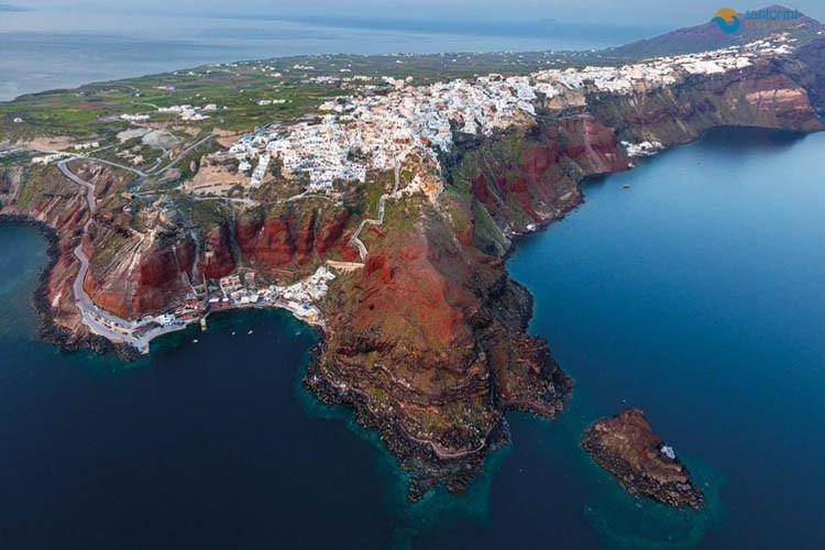
A geological tour of santorini is the island read as a volcano rather than as a view: the caldera cliff as a cross-section of half a million years of eruptions, the town at Akrotiri buried by the largest of them, the Kameni islets still being built in the middle of the crater, and the coloured beaches where the separate eruptions reach the sea.
Geological tour of Santorini
Geological studies show that the first volcanic activity in the general region of Santorini began about 2.5 million years ago and created the complex of Christians. In the narrow area of Santorini, the volcano was active about 1 million years ago and within the last 400,000 years it exploded paroxystically at least 12 times.
These explosions occur every 20,000 years and create huge craters of collapse. Between the eruptions that destroy the island, milder intervals of various duration are inserted, during which a lot of eruptions of lesser extent rebuild it slowly.
Santorini Tours is the best way to have the geological tour of Santorini that you would love.
The succession of explosions
Santorini’s volcanic activity affects a tectonic fault that begins with the Christians, passes from Santorini and ends up in Amorgos. This point remains active and is the cause of the 1956 earthquake.
The volcanic development of Santorini follows, therefore, a circular succession of explosions.
For many millennia, the volcano has been active without paroxysmal events. The lava that in the meantime accumulates, expands and gradually elevates through the volcanic cones. The higher they ascend, however, the longer the magma must follow the path to come to the surface, the more difficult it escapes, and the more premature it is favored in the cones. Gradually, the Thira magma cools and solidifies into the cones before it reaches the surface, blocking the craters.
After clogging, there is a long period of relative silence, during which large amounts of magma are trapped in underground spaces and increase escape pressure, which is extinguished every now and then, though not enough, by small bursts of explosive resources. But when the pressure in the underground spaces exceeds the weight and the consistency of the overlying cones in strength, then the magma opens to the surface with paroxysmal intensity, crushing and blowing up all the obstacles on its way. Together with the magma comes out superheated steam, spilled on the surface and transformed into water vapor.
The last two paroxysmal eruptions in Santorini occurred about 21 and 3.6 thousand years ago, respectively. The latter is placed in the Minoan period and more specifically in the second half of the 17th century BC. century.
The caldera of Santorini, however, was not formed at the time. It was gradually created by many precipitations at different times of volcanic action, which formed the geomorphology of the island from time to time. Santorini transfers is the best way to explore the island.
Find out the beauty and the uniqueness of Santorini by booking now one of the following tours of Santorini:
- Santorini full day private tour
- Santorini sightseeing private tour
- Santorini exclusive shore private tour
- Santorini impressive Caldera private tour
- Santorini south part private tour
- Santorini north part private tour
- Santorini historical private tour

The Kouloumpos volcano
This submarine volcano is located 6.5 km southeast of the island of Santorini. It was discovered in 1650, during a volcanic eruption lasting 2-3 months (from September to December 1650). An islet appeared at the point of the underwater explosion, but a little later disappeared.
Today, the 18 meter long Koulbubo reef is the shallowest point of the underwater volcano cone, which has a diameter of 1.5 kilometers and surrounds the crater having a depth of 500 meters
See more about Santorini island:
- Cycladic architecture, an unsurpassed heritage in Santorini
- Santorini car hire
- Red beach in the most most spectacular colorful beaches in the world
- Luxury vacations in Santorini
- Beach wedding in Santorini
Geological Tour of Santorini: The Short Answer
A geological tour of santorini is the island read as a volcano rather than as a view. It runs to four places: the caldera cliff, which is a cross-section of half a million years of eruptions; the excavation at Akrotiri, buried by the largest of them; the Kameni islets in the middle of the crater, which are still being built; and the coloured beaches of the south, where the different eruptions reach the sea.
You can do it privately by road in a day, add the volcano boat, and take a guide who explains the layers rather than the sunsets. Half a day covers the cliff and the beaches; a full day adds Akrotiri and Nea Kameni.
The single thing to understand before you start: the crescent you are standing on, the island of Thirasia opposite and the bare rock of Aspronisi between them are three fragments of one circular island whose centre is now four hundred metres under water.
A Geological Tour of Santorini Starts at the Caldera Cliff
The pale cap, the first thing any geological tour of santorini points at. Thirty to sixty metres of white and pink pumice and ash from the Minoan eruption of around 1600 BC. It is the youngest thing on the cliff and the reason the island is the shape it is.
The dark bands beneath, the older half of a geological tour of santorini. Lava flows and older eruptions stacked over hundreds of thousands of years, each a separate island-building event.
The red and rust patches. Oxidised scoria from vents on this side, strongest around Ammoudi and the northern cliffs.
The thin dark lines. Palaeosols — old soil horizons — marking the quiet centuries between eruptions.
The dykes. Vertical intrusions cutting up through the horizontal layers, where magma forced its way to the surface.
Where to read it. From the rim path between Fira and Imerovigli, from the top of the cable car, and best of all from a boat in the middle of the bay.
What it means. On any geological tour of santorini this cliff is the primary document; everything else on the island is a footnote to it.
The Eruption Cycles Behind a Geological Tour of Santorini
The beginning. Volcanic activity here started around two million years ago on the site of an older limestone island, whose remains are still visible at Profitis Ilias and Monolithos.
Twelve major explosive cycles. Geologists count roughly twelve large eruptions over the past 360,000 years, each building the cone up and then blowing part of it away.
The Lower Pumice eruptions. Around 180,000 and 172,000 years ago, both caldera-forming.
The Cape Riva eruption. About 22,000 years ago, which created the caldera that existed before the last one.
The Minoan eruption, the centre of every geological tour of santorini. Around 1600 BC, one of the largest of the Holocene, several times the size of Krakatoa, which removed the centre of the island.
Since then. Nea Kameni and Palia Kameni have been built out of the water by eruptions from 197 BC onwards, the most recent in 1950.
The present. On a geological tour of santorini the volcano is dormant rather than extinct, monitored continuously, and it produced a period of unrest in 2011 and 2012 with no eruption.
The Minoan Eruption on a Geological Tour of Santorini
Everything a geological tour of santorini shows you converges on one event, and it is worth understanding at more than postcard level. Around 1600 BC — the exact date is still argued between radiocarbon evidence and archaeological chronology, which is one of the liveliest disputes in Aegean science — the volcano erupted with a force that put somewhere between forty and sixty cubic kilometres of magma into the air and the sea.
On a geological tour of santorini you can see it happened in phases rather than in one blast. The first was a Plinian column: a vertical eruption column tens of kilometres high, dropping a blanket of white pumice across the island and downwind across the eastern Mediterranean. That is the layer you can see and touch in the cliff and in every road cutting on the island, and it is the layer that buried and preserved the town at Akrotiri. The second and third phases were pyroclastic surges and flows — ground-hugging clouds of gas and rock moving at hundreds of kilometres an hour — which laid down the thicker, coarser deposits above the pumice.
Then the roof fell in, which is what a geological tour of santorini is really about. With the magma chamber emptied, the centre of the island collapsed into the void, and the sea poured through the breach on the western side. What is now four hundred metres of water in the middle of the bay was, a few days earlier, the middle of an island. The collapse generated tsunamis that reached Crete and the Anatolian coast.
The consequences are still argued about. Minoan Crete, a hundred and ten kilometres south, was not destroyed by the eruption — the archaeology shows the palaces surviving and declining afterwards rather than at the moment — but the ash fall, the tsunamis and the disruption to a maritime economy were plainly severe. And the story of a wealthy island civilisation ending suddenly beneath the sea has been attached to Plato’s Atlantis since Spyridon Marinatos proposed the link in 1939. That is a plausible piece of raw material rather than a proven identification, and any honest geological tour of santorini says so.
Where to Stand on a Geological Tour of Santorini
Akrotiri, the human stop on a geological tour of santorini. The Bronze Age town under the ash, roofed and walkable, with the pumice layer visible in the excavation walls above the streets.
The Red Beach, the most photographed geological tour of santorini stop. A cinder cone cut in half by the sea, oxidised iron-red, with the layering of a single vent exposed in the cliff.
The White Beach and the Vlychada cliffs. Pure Minoan ash and pumice, compacted and carved by wind into fluted shapes.
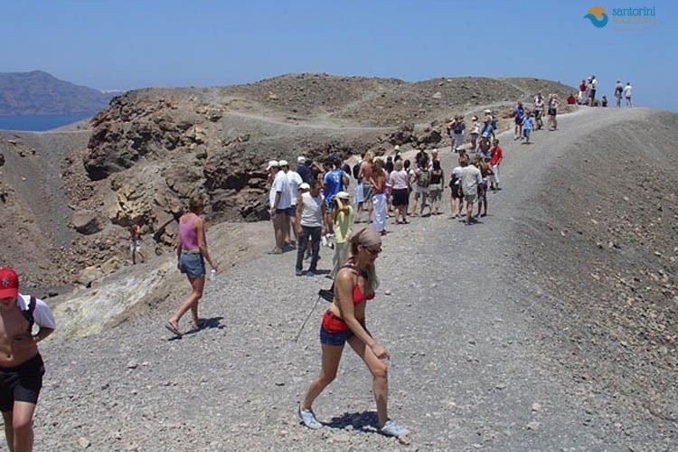
Nea Kameni. A twenty-five minute walk up loose black cinder to a crater rim, with fumaroles, warm ground and lava flows dated from 197 BC to 1950.
Palia Kameni. The hot springs, where mineral-rich water vents through the seabed and stains the rock and the water rust-orange.
Profitis Ilias and Monolithos. The pre-volcanic basement: metamorphic limestone and schist, hundreds of millions of years older than everything around them.
The Kolumbo crater. Seven kilometres north-east, underwater, and the most active part of the whole system. Invisible from land and the reason the seismographs matter.
Akrotiri: A Geological Tour of Santorini Made Human
The excavation at Akrotiri is usually sold as archaeology and it belongs on a geological tour of santorini for a simple reason: it is the only place where you can stand inside the eruption’s own evidence and see what it did to people.
What was buried was a substantial Bronze Age town — three-storey houses, paved streets, a drainage system with clay pipes running under them, hot and cold running water, and wall paintings in ordinary domestic rooms rather than only in palaces. It was a trading port in contact with Crete, Egypt and the Levant, and by any reasonable measure it was rich.
What preserved it, as any geological tour of santorini explains, is the same thing that ended it. The first phase of the eruption dropped several metres of light pumice over the town, which filled the rooms without crushing them, sealed the organic material and held the walls upright. The later surge deposits sat on top of that and locked the whole site in. When Spyridon Marinatos began excavating in 1967, what came out was a town rather than a ruin: pots standing where they were left, furniture that survived as voids in the ash and could be cast in plaster, staircases, beds and a grinding stone.
The detail everybody remembers from a geological tour of santorini is the absence. There are no bodies at Akrotiri, and no gold or valuables of the kind found at comparable sites. Damaged walls repaired before the eruption suggest earthquakes gave warning, and the population appears to have left with what it could carry. Somewhere out there is a story of an evacuation, and nobody knows where those people went.
Stand on the walkway and look up at the section above the streets and the layers of the eruption are directly overhead in order: the pumice fall first, the surges above it. That is the same sequence you can see in the caldera cliff eight kilometres away, and joining those two observations is the point of the whole day.
Why a Geological Tour of Santorini Explains the Wine
The agriculture is a geological consequence, and it is the part of a geological tour of santorini that the wine tours never quite explain. Santorini receives around 350 millimetres of rain a year, almost none of it between May and October. There is no river, no spring and no water table worth the name. What plants grow in is not soil but aspa — volcanic ash, pumice and lava debris.
Pumice is the reason anything survives on a geological tour of santorini route. It is porous to the point of being mostly air, and it draws moisture out of the humid night air and holds it against the roots. That single property is why an ungrafted vine can live for two hundred years here without irrigation, and why the fruit is small, concentrated and high in acid.
The ash has a second useful property: phylloxera, the root louse that destroyed most of Europe’s vineyards in the nineteenth century, cannot survive in it. Santorini’s vines were never grafted onto American rootstock and some of the root systems are among the oldest continuously producing in the world.
The wind explains the shape the vines take on a geological tour of santorini. Vines here are woven into low circular baskets on the ground — kouloures — with the fruit growing on the inside, protected from a meltemi that would strip a trellised vine bare. Nothing about that is picturesque tradition; it is engineering for a specific climate on a specific rock.
And the ash had an industrial life too. Theran earth, the pozzolanic ash quarried on this island for a century, was shipped out by the boatload to build the Suez Canal, because volcanic ash mixed with lime sets underwater. The quarries are still visible on the caldera cliffs at Therasia and above Athinios, and they are the reason parts of the rim look bitten into.
Kolumbo, the Volcano No Geological Tour of Santorini Reaches
Seven kilometres north-east of Oia, five hundred metres below the surface, sits a crater a kilometre and a half across that most visitors have never heard of. Kolumbo is the other half of Santorini’s volcanic system and, on current evidence, the more active half.
It erupted in 1650, and that eruption killed around seventy people on Santorini — not through lava but through gas. The plume reached the surface, released carbon dioxide and other volcanic gases that flowed downhill and pooled in low ground, and people and animals in the north of the island suffocated. It also generated a tsunami that struck the coasts of Santorini, Ios and Crete. It remains the deadliest volcanic event in Greek recorded history.
Today the crater floor is covered in active hydrothermal vents, some of them above a hundred degrees, building chimneys of mineral deposits and supporting a bacterial ecosystem that has been studied since the 2000s. Research submersibles and mapping surveys have found a magma chamber beneath it at about four kilometres depth, and the seismic activity in the wider system is monitored continuously by the Institute for the Study and Monitoring of the Santorini Volcano.
None of this is a reason not to come, and it is a reason to understand what you are standing on. A geological tour of santorini that stops at the pretty cliff has told you half the story; the system is alive, it is monitored, and the last time it did something significant, it did it from underwater and from the direction nobody was watching.
The Rocks Underfoot on a Geological Tour of Santorini
Pumice, the signature rock of a geological tour of santorini. The white-grey stone the whole island is dusted in. Full of gas bubbles, light enough to float, and the reason the vines survive without rain — it pulls moisture out of the night air.
Ash and tuff. Compacted volcanic ash, soft enough to cut, which is why the island’s houses are dug into cliffs rather than built on them.
Basalt and andesite, the black half of a geological tour of santorini. The dark lava flows, hard and sharp, forming the black beaches and the Kameni islets.
Scoria. Red-brown cinder from fire-fountain eruptions, oxidised by iron. The Red Beach is a cross-section of it.
Theran earth. The pozzolanic ash quarried here for a century and shipped to build the Suez Canal, because volcanic ash and lime make a cement that sets underwater.
The basement. Limestone and schist at Profitis Ilias, Monolithos and Gavrilos — the pre-volcanic island the whole system was built on top of.
What you cannot take. Removing rock or pumice from archaeological areas and protected beaches is prohibited, and the Red Beach in particular is monitored.
A Geological Tour of Santorini, Hour by Hour
09:00. Begin the geological tour of santorini at Akrotiri, in the first hour after opening: the town, the ash layer above it and the fresco fragments still in situ.
10:30. The Red Beach viewpoint from the headland, and the White Beach and Vlychada cliffs after it.
12:00. The lighthouse at the southern tip, where the pre-volcanic basement meets the volcanic cover.
13:00. Lunch at Vlychada or Emporio, out of the sun.
15:00. The Museum of Prehistoric Thera in Fira, which puts the human half of the story next to the geological one.
16:30. Profitis Ilias for the basement limestone and the view of the whole caldera at once.
18:00. End the geological tour of santorini on the rim path at Imerovigli, reading the cliff opposite in the evening light, which is when the layers show best.
Is a Geological Tour of Santorini Safe? What the Monitoring Says
Everybody asks and the answer deserves more than reassurance. Santorini sits on the Hellenic volcanic arc, where the African plate is subducting beneath the Aegean, and it is one of the most closely watched volcanoes in Europe. The Institute for the Study and Monitoring of the Santorini Volcano runs a permanent network of seismometers, GPS stations and gas sensors across the island and the Kameni islets, and the data feeds into national and European monitoring programmes.
The system a geological tour of santorini walks over does produce unrest. In 2011 and 2012 there was a period of inflation: the caldera floor rose by several centimetres, small earthquakes clustered under the Kameni islets, and the magma chamber was estimated to have taken in a significant volume of new material. It did not erupt, the inflation stopped, and the system returned to background levels. That episode is the reason the monitoring network is as dense as it is today.
The seismic swarms that occasionally make international news — including the significant sequence between Santorini and Amorgos in early 2025 — are usually tectonic rather than volcanic, generated by faults in the surrounding crust rather than by magma moving under the island. Distinguishing the two is exactly what the monitoring network exists to do, and it is done in near real time.
What that means for a visitor is straightforward. The volcano is dormant, not extinct; an eruption would be preceded by weeks or months of measurable warning; and the authorities have a civil protection plan built around that warning. It also means the ground you are walking on for a geological tour of santorini is not a museum exhibit. Nea Kameni was last in eruption in 1950, which is within living memory, and the fumaroles at the crater rim are venting today.
Museums to Add to a Geological Tour of Santorini
The Museum of Prehistoric Thera, the indoor half of a geological tour of santorini. The frescoes and finds from Akrotiri, and the best hour on the island for making sense of what you saw at the excavation.
The Archaeological Museum, the later half of a geological tour of santorini. Later material, from Ancient Thera and the Classical and Roman periods.
The site museum at Akrotiri. Interpretation boards on the walkways that explain the eruption sequence directly above your head.
The Tomato Industrial Museum, Vlychada. Not geology, and it explains what farming on ash actually meant economically.
The Lost Atlantis Experience, Megalochori. A commercial exhibition with a good eruption model, useful for children on a geological tour of santorini.
The Volcanological Institute. Not open to casual visitors, and its published data and bulletins are public and readable.
What to read. The USGS chapter on Santorini’s geological and tectonic setting is free, short and the best short technical summary available.
Doing a Geological Tour of Santorini Properly in One Day
The mistake is doing a geological tour of santorini in the order the coaches drive rather than the order the island was made. Start at Profitis Ilias or Monolithos, where the pre-volcanic limestone basement is exposed, so you begin with the island that existed before any of this. Move to the south coast for the cinder cone at Red Beach and the Minoan ash at White Beach and Vlychada — the individual eruptions, one at a time, at eye level.
Then Akrotiri, which puts a date on the geological tour of santorini and a human consequence on the largest of them. Then, in the afternoon, the caldera rim, where the whole sequence is stacked in one cliff face and where an evening light rakes across the layers and separates them better than midday sun ever does. If you have the boat as well, put it last: Nea Kameni is the sequel, the part that has happened since, and it lands better once you know what came before.
Two hours of that is worth more than a week of photographing the same view, and it is entirely doable in a day with a driver who knows which order to take it in. A geological tour of santorini done that way turns a pretty island into a legible one, and it is the single change that most improves how the rest of a trip here feels.
The Volcano Boat on a Geological Tour of Santorini
Every visitor takes the boat to Nea Kameni and most of them walk up it without being told what they are walking on. The island is a lava dome complex, built entirely since 197 BC, when the first of the Kameni eruptions broke the surface of the flooded crater. Everything under your feet is younger than the Roman Empire.
The geological tour of santorini path climbs about a hundred and thirty metres through loose black cinder to a set of nested craters. Look for three things. The colour changes: fresh flows are near-black, older ones weather to grey and rust. The fumaroles: cracks around the crater rim that vent sulphurous gas, warm to the hand, smelling of struck matches. And the flow fronts: the steep, blocky faces where a lava tongue stopped and cooled, several of which are dated on the interpretation boards to specific eruptions — 1866, 1925, 1939, 1950.
Palia Kameni, the last stop of a geological tour of santorini by sea, is where the boats stop for the hot springs. Water heated by the system rises through the seabed in a cove there, mixes with the sea at around thirty degrees and precipitates iron oxide, which is what stains the water and the rock orange and what will permanently stain your swimwear. The colour is the geology working in real time, and it is the closest most people get to touching an active volcanic system.
A guided boat with a geologist on board costs more than the standard trip and is the single best upgrade on a geological tour of santorini. Failing that, take the standard boat, read the boards at the crater rim and give yourself twenty minutes at the top rather than the ten most groups allow.
Geological Tour of Santorini: Frequently Asked Questions
What is a geological tour of santorini? A day that reads the island as a volcano: the caldera cliff, Akrotiri, the coloured beaches and the Kameni islets, with a guide who explains the layers.
Is Santorini’s volcano still active? Dormant rather than extinct. The last eruption was in 1950 and the system is monitored continuously.
When was the big eruption? Around 1600 BC, though the exact date is still disputed between radiocarbon and archaeological dating.
How big was it? Somewhere between forty and sixty cubic kilometres of magma, several times the size of Krakatoa in 1883.
Did it destroy the Minoans? Not directly. Crete survived the eruption and declined afterwards; the link is plausible and contested.
What is Kolumbo? An underwater crater seven kilometres north-east, more active than the main system, which erupted lethally in 1650.
Can you walk on the volcano? Yes, on Nea Kameni: twenty-five minutes up loose cinder to the crater rim, hot and unshaded.
How deep is the caldera? Close to four hundred metres in places, which is why the water changes colour so sharply offshore.
Why is the sand black and red? Black is basalt lava ground down; red is oxidised iron in scoria from a cinder cone.
Where is the best place to see the layers? From a boat in the middle of the caldera, or from the rim path at Imerovigli in the evening.
Can you take rocks home? No. Removing material from archaeological areas and protected beaches is prohibited.
How long does the tour take? Half a day for the cliff and the beaches, a full day with Akrotiri and the volcano boat.
Geological Tour of Santorini: We Will Take You Round the Volcano
We are a local operator running private tours and transfers in our own vehicles, and a geological tour of santorini is the day we most enjoy driving: Akrotiri at nine, the coloured beaches before the heat, the basement limestone at Profitis Ilias, and the cliff read from the rim in the evening light.
Tell us your dates and whether you want the boat as well, and we will build the day so the sites come in the order the geology happened rather than the order the coaches use.
Prices are per vehicle rather than per person, hotel pickup anywhere on the island is included, we guide in twelve languages, and an 80 EUR deposit confirms a date.
See the personalised tour, the historical tour, or contact us.
Every Village and Site on the Island
Any of these can be built into a private day. Each has its own page with what to see and how long to allow.
Caldera villages: Fira · Firostefani · Imerovigli · Oia · Finikia · Baxedes
Inland villages: Pyrgos · Megalochori · Emporio · Mesaria · Karterados · Vothonas · Vourvoulos · Exo Gonia · Mesa Gonia · Pigadia
Beaches: Perissa · Perivolos · Kamari · Vlychada · Monolithos · Red Beach · White Beach · Agios Georgios · Agia Paraskevi
Sites and landmarks: Akrotiri · Ancient Thira · Akrotiri Lighthouse · Nea Kameni · Palia Kameni · Thirasia · Athinios Port
All our tours: All Santorini tours · Full day tour · Sightseeing tour · Personalised tour · North part tour · Horse riding · South part tour · Sunset tour · Shore excursion · Caldera tour · Food experience · Wine tour · Historical tour · Small group tour
Planning and services: Famous sights tour · Private transfers · Transfers to Oia and Finikia · Transfers to other villages · Villages of Santorini · History of Santorini · Tours near you · Languages we guide in · Food and fun tours · Gay friendly tours · Our tour buses · Daily tours · Day tours · FAQ · Gallery · Tour photo gallery · About us · Contact · Blog