
The santorini hiking trails are not a single famous walk with a few offshoots; they are a network of old donkey paths, cliff-edge lanes, ridge climbs and beach traverses that cover most of the island, and almost all of them are free, unmarked in places and empty before nine in the morning. Our drivers drop walkers at trailheads every week in season and collect them at the far end, so the notes below are written from the ground rather than from a map. If you would rather the logistics were handled, start at Santorini tours.
What follows covers every route worth your morning: distances, real walking times, where each one starts, how hard it is, when to go, what the ground is like underfoot, and how to get back without a car.
The Nine Santorini Hiking Trails Worth Walking
Ranked by how often we are asked about them rather than by difficulty.
Fira to Oia on the rim. About ten kilometres along the caldera edge through Firostefani and Imerovigli, three to four hours with photograph stops. The single most famous of the santorini hiking trails and the one that earns its reputation.
Kamari to Ancient Thira. A steep zigzag up Mesa Vouno to a Hellenistic and Roman city on a ridge 360 metres above the sea, an hour up and forty minutes down.
Perissa to Ancient Thira. The other side of the same mountain, longer, rougher and quieter, about ninety minutes up.
Profitis Ilias to Pyrgos. A ridge walk from the island’s highest point down through vineyards to the castle village, roughly an hour and a half, mostly downhill.
The Nea Kameni crater. Thirty minutes of loose volcanic gravel from the boat landing to the rim of a live crater, done as part of a caldera cruise.
Vlychada to Eros beach. A short coastal scramble under white wind-carved cliffs, twenty minutes each way, best in the late afternoon.
Akrotiri to the lighthouse. Three kilometres of quiet road and track to the southern tip, with the whole caldera opening behind you.
Exo Gonia to Mesa Gonia. A gentle vineyard link between two eastern villages, thirty minutes, and almost nobody walks it.
Oia to Baxedes. Down the northern slope to the quiet beaches below Oia, twenty-five minutes down and a hard climb back.
Fira to Oia: The Rim Path in Detail
If you walk one of the santorini hiking trails, walk this one. It follows the edge of a drowned volcano for ten kilometres and the view changes at every corner.
Where the rim path on the santorini hiking trails starts. At the northern end of Fira, past the cable car station, where the paved path leaves the last hotels and runs along the cliff.
The first stretch. Fira to Firostefani to Imerovigli is paved, level and busy, about forty-five minutes of terraces and blue domes.
The climb after Imerovigli. The path leaves the villages behind and climbs a bare hillside to a chapel, the first real effort of the day and the point where most people turn back.
The middle. An hour of open ridge with no shade, no shops and no water, red and black rock underfoot, the caldera 300 metres below on your left.
The descent into Oia. A long, gentle drop with the village appearing white on its headland, which is the photograph people come for.
Times on this stretch of the santorini hiking trails. Three hours at a brisk pace, four with stops, longer if you stop for coffee in Imerovigli.
Which direction. Fira to Oia is standard because you finish at the famous end. Walking it in reverse puts the sun behind you in the afternoon and lets you finish with a taxi rank rather than a bus queue.
The half version. Fira to Imerovigli takes an hour, covers the best-looking stretch and ends at a bus stop.
Ancient Thira: The Hardest Climb and the Best Reward
Two of the santorini hiking trails climb Mesa Vouno to the same place from opposite sides, and both are serious in summer heat.
The santorini hiking trails from Kamari. The path leaves the southern end of the beach and zigzags up the rock face. Sixty to seventy-five minutes of steady climbing with the sea underneath you the whole way.
The santorini hiking trails from Perissa. Longer and rougher, starting behind the village and taking about ninety minutes, with far fewer people on it.
What is at the top. A city founded in the ninth century BC and built up by the Ptolemies and the Romans, with streets, an agora, a theatre carved into the slope and a view over both coasts.
The catch. The site keeps its own opening hours and closes in the early afternoon, so start at seven or eight in the morning.
Ground and footwear. Loose stone on a steep gradient. Trainers at minimum, never sandals.
Water. Carry two litres a head. There is nothing on the mountain.
Getting back. Walk down the other side and finish on a different beach, which turns a climb into a proper traverse.
Profitis Ilias and the Vineyard Ridge
The quietest of the high santorini hiking trails, and the only one that shows you the whole island at once.
The start of this ridge route on the santorini hiking trails. At the monastery on the summit of Profitis Ilias, 567 metres up, reached by road or by a steep path from Pyrgos.
The view. On a clear morning you see the caldera on one side, the airport and the eastern beaches on the other, and the outline of Ios and Anafi on the horizon.
The walk down. A ridge track drops through vineyards towards Pyrgos in about an hour and a half, all of it downhill.
The link to Ancient Thira. A rougher path continues along the ridge towards Mesa Vouno for walkers who want a long day.
Best season. March to May, when the vines are green and the ridge is covered in wild flowers.
The finish. Pyrgos has shade, tavernas and a bus back to Fira, which makes it the right end of the walk rather than the start.
The Volcano Walk on Nea Kameni
The only one of the santorini hiking trails that starts from a boat, and the only one on ground younger than the village you are staying in.
How you reach this one of the santorini hiking trails. A caldera cruise from the Old Port below Fira or from Ammoudi, twenty minutes across the water to the black island in the middle.
The walk itself. Thirty to forty minutes up a wide gravel path to the crater rim at about 130 metres, then a loop around the vents.
What you see. Steam escaping from cracks, sulphur staining the rock yellow, and the whole rim of the caldera standing above you like the wall of a stadium.
Difficulty on this stretch of the santorini hiking trails. Easy underfoot but completely exposed, and the black gravel holds heat.
What to bring. Closed shoes, a hat, water and sunglasses. The dust gets everywhere.
The swim afterwards. Most boats stop at Palea Kameni, where warm springs stain the sea rust orange. Wear a swimsuit you do not love.
Our page on it. The route and the boat options are covered on the walk to the volcano.
Short Walks When You Only Have an Hour
Not every one of the santorini hiking trails needs a morning. These five fit around a lunch.
Firostefani to Imerovigli, the gentlest of the santorini hiking trails. Twenty minutes of paved rim with the best single stretch of caldera view on the island.
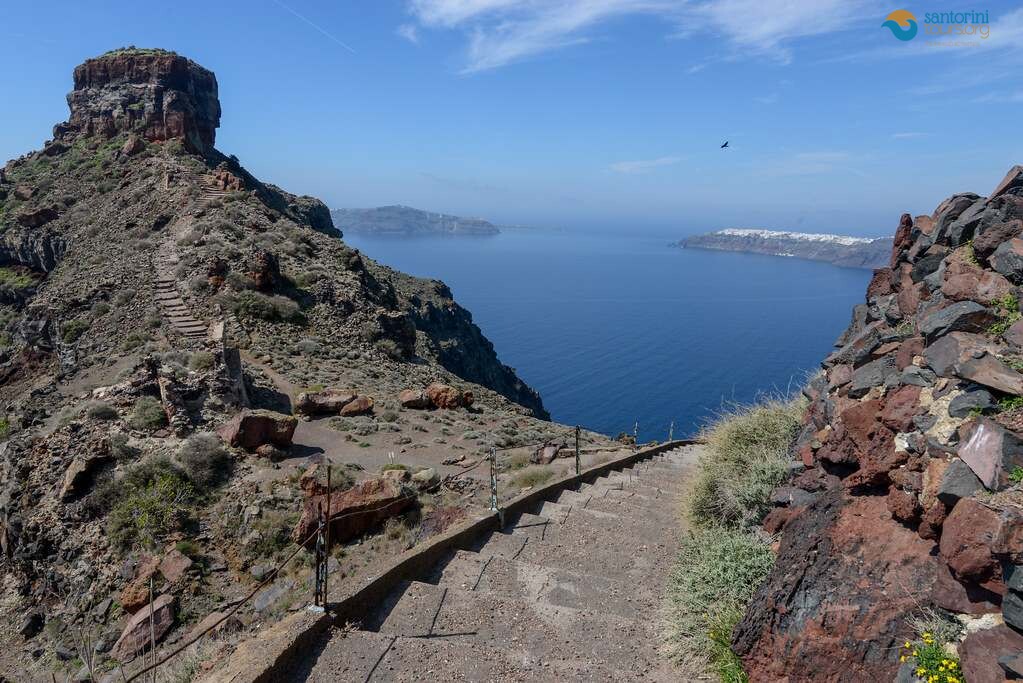
Skaros rock. Down the steps from Imerovigli and out onto the headland where the medieval castle stood, forty-five minutes there and back, with a chapel on the far side.
Vlychada to Eros. Twenty minutes under white cliffs carved into fins and hollows by the wind, and the strangest landscape on the island.
Akrotiri to Faros. Three kilometres of quiet road to the lighthouse at the southern tip, best in the last hour of light.
Emporio kastelli. Not a hike but a maze, a medieval village built to confuse invaders, and twenty minutes of getting lost on purpose.
Mesa Pigadia. A track down to a small fishing cove below the red cliffs of the south coast, fifteen minutes down and a warm climb back.
Difficulty, Honestly Rated
Greek island paths are rarely signposted with grades, so here is a plain rating for the main santorini hiking trails.
Easy sections of the santorini hiking trails. Fira to Imerovigli, Firostefani to Imerovigli, Akrotiri to the lighthouse, Exo Gonia to Mesa Gonia. Paved or level, no exposure, suitable for most people in trainers.
Moderate. The full rim path to Oia, Profitis Ilias down to Pyrgos, Nea Kameni. Long or hot rather than technical, with one real climb each.
Hard sections of the santorini hiking trails. Kamari or Perissa up to Ancient Thira, and the ridge link between Profitis Ilias and Mesa Vouno. Steep, loose and fully exposed to the sun.
What makes them hard here. Not gradient but heat, sun and the lack of water. A moderate path in May is a hard one in August.
Vertigo. The rim path runs close to a long drop in a few places, though it is wide and walled for most of its length.
Children. The short paved sections work well from about six. The climbs to Ancient Thira do not.
When to Walk: Season and Hour
Timing matters more than fitness on this island, because there is almost no shade anywhere.
The best months on the santorini hiking trails. April, May, late September and October. Warm, clear and green in spring, with the sea still swimmable in autumn.
The hardest months. July and August, when the rock radiates heat all afternoon and the santorini hiking trails should only be walked at dawn.
Winter. Perfectly walkable and often beautiful, with grass on the slopes and empty paths, though some tavernas along the way are shut.
The right hour in summer. Start at six or seven in the morning and be finished by ten. Sunrise from the rim path is worth the alarm on its own.
The second window. After five in the afternoon, when the cliffs turn copper and the crowds are heading for the sunset instead.
Wind. The meltemi makes summer walking cooler but pushes hard on the exposed ridges, so hold on to hats and phones.
Rain. Rare between May and September. When it does come, the volcanic dust turns slick, so leave the steep ground alone.
What to Carry
A short list, and every item on it matters on the santorini hiking trails.
Water on the santorini hiking trails. Two litres a person for anything over an hour. There are no springs and no taps on the paths.
Shoes with grip for the santorini hiking trails. Loose volcanic gravel behaves like ball bearings on a slope. Trainers minimum, walking shoes better, sandals never.
Sun protection. Hat, sunglasses, high-factor sunscreen applied before you start and again halfway.
A windproof layer. The ridges are cool at dawn and blustery by mid-morning.
Food. There is nothing to buy between Imerovigli and Oia, or anywhere on Mesa Vouno.
A charged phone. Signal is good almost everywhere, and the map matters where the path forks.
Cash. Small tavernas at the far end of a walk do not always take cards.
Getting to the Trailheads Without a Car
Most of the santorini hiking trails start in a village with a bus stop, which makes a car optional.
Buses to the santorini hiking trails. The network runs out of Fira to Oia, Kamari, Perissa, Akrotiri, Pyrgos and the port, with the first departures early enough for a dawn start in summer. Fares are a few euros a leg and the routes are on our page about the island buses.
The walk back problem. One-way routes are the best ones, so plan the return before you set off rather than at the far end.
Taxis. The island’s fleet is small and hard to find at trailheads. Do not count on flagging one at Perissa at two in the afternoon.
Private transfer. A driver who drops you at the start and meets you at the end removes the only real friction in a walking day, and lets you walk the good direction rather than the convenient one.
Rental ATV. Useful for reaching Profitis Ilias or Faros, useless for one-way walks.
The best combination on the santorini hiking trails. Bus out early, walk, taverna lunch at the far end, bus or driver back in the afternoon.
What You Are Walking On
The ground explains most of what makes the santorini hiking trails unusual.
Pumice and ash under the santorini hiking trails. The white rock you cross above Vlychada and along parts of the rim is compacted ash from the eruption of about 3,600 years ago, soft enough to be carved by wind.
Lava and scoria. The red and black layers in the cliff face are older flows, and the red beaches are what happens when one of them meets the sea.
The caldera edge. A collapse scar, not a hillside. The path along it is walking the wall of a crater that is mostly under water.
The young islands. Nea Kameni and Palea Kameni rose inside the flooded crater from later eruptions, the most recent in the twentieth century, which is why the rock still steams.
The vines. Trained into low baskets on the ground against the wind, growing in ash with almost no rain, a method you will walk past on every inland route.
The old paths. Many of these routes were donkey tracks between villages and fields long before anyone walked them for pleasure.
Why it matters. Knowing what you are standing on turns a view into a story, which is the difference between a walk and a day you remember.

Sunrise, Sunset and Photographs on the Trails
The light does more for these routes than any lens.
Sunrise on the rim of the santorini hiking trails. Start from Fira at first light and the villages are empty, the sea is flat and the cliffs go pink. The best hour of the day on the santorini hiking trails.
Imerovigli at dawn. Skaros rock in silhouette with the caldera behind it, and nobody else on the path.
Ancient Thira in early light. The columns catch the sun before the heat arrives, and the walk up is bearable.
Late afternoon at Vlychada. The white cliffs turn gold and the shadows show their carved texture.
Sunset from Profitis Ilias. The whole island below you with the light going down behind the caldera rim.
What to avoid. Midday on the ridge, when the light is flat, the heat is serious and every photograph looks the same.
Safety and Common Sense
Nothing here is alpine, but people do get into trouble, and almost always for the same reasons.
Heat is the real hazard on the santorini hiking trails. Most incidents on the santorini hiking trails involve dehydration, not falls.
Tell someone your route. Especially on the Mesa Vouno climbs, where you can be out of sight of the beach within ten minutes.
Stay on the path on the santorini hiking trails. Shortcuts on volcanic slopes cause rockfall and erosion, and some cliff edges are unstable.
Respect closures. Access to Red Beach and parts of the south coast changes with rockfall warnings, and fences are there for a reason.
Start early, not late. Running out of daylight on an unlit ridge is avoidable and unpleasant.
Emergency number. 112 works across Greece and connects to English-speaking operators.
Walking alone. Fine on the rim path, less sensible on the ridge routes in high summer.
Where Each Trail Starts, Exactly
Trailheads are the part nobody writes down, and the reason walkers lose twenty minutes at the beginning of the day.
The rim path on the santorini hiking trails. Walk north through Fira past the cable car station and the Orthodox cathedral; the path leaves from behind the last row of hotels and is paved from the start.
Skaros rock. From the church square in Imerovigli, take the steps that drop to the left of the terraces; the headland is in front of you the whole way.
Kamari to Ancient Thira. At the far southern end of the Kamari seafront, past the last hotel, where a track climbs behind the rocks and becomes a zigzag.
Perissa to Ancient Thira. Behind the village church, on the road that heads inland and turns into a stony path up the flank of Mesa Vouno.
Profitis Ilias. At the monastery gate on the summit, where the ridge track heads south towards Pyrgos and the vineyards.
Vlychada to Eros. From the beach car park, walk west along the sand until the white cliffs begin, then follow the shoreline.
Akrotiri to the lighthouse. From the village square, take the road signposted to Faros and stay on it; the last kilometre is quiet enough to walk in the middle.
Oia to Baxedes. From the bus terminal end of Oia, a track drops north through the fields towards the coast road.
Nea Kameni. The only one of the santorini hiking trails with a ticket desk, on the quay where the caldera boats tie up.
Times and Distances at a Glance
Numbers for planning, measured at an ordinary walking pace with a few stops.
Fira to Oia. Ten kilometres, three to four hours, one sustained climb, no shade after Imerovigli.
Fira to Imerovigli. Three kilometres, one hour, paved throughout and the easiest of the santorini hiking trails with a big view.
Kamari to Ancient Thira. Two kilometres but 350 metres of ascent, an hour to an hour and a quarter up.
Perissa to Ancient Thira. Three kilometres, ninety minutes up, rougher underfoot.
Profitis Ilias to Pyrgos. Five kilometres, an hour and a half, almost all downhill.
Nea Kameni crater loop. Two kilometres, forty minutes, loose gravel and no shelter.
Vlychada to Eros. One kilometre each way, twenty minutes, flat along the shore.
Akrotiri to Faros. Three kilometres, forty-five minutes, road walking with a spectacular ending.
Skaros headland. One kilometre, forty-five minutes there and back, steps down and steps back up.
Combining a Walk With a Swim, a Winery or a Village
The best days here are not pure walking days, and the santorini hiking trails lend themselves to being half of something.
Walk then swim. Ancient Thira from Kamari, down the far side, and straight into the sea at Perissa. The best combination on the island.
Walk then taste. Profitis Ilias down to Pyrgos, then a winery on the plain below, which is a fifteen-minute drive or a long, flat walk.
Walk then eat. The rim path finishing at Ammoudi, where the fish tavernas sit at the waterline under Oia.
Walk then look. Akrotiri the archaeological site in the cool of the morning, then the lighthouse walk when the light turns.
Walk then float. Nea Kameni’s crater followed by the warm springs at Palea Kameni, which is the only swim on the island that smells of sulphur.
Walk then nothing. Firostefani to Imerovigli at dawn, back to the hotel by eight, and the whole day still ahead of you.
Three Walking Days, Built From the Trails
How to string the santorini hiking trails together if walking is the point of your visit.
Day one on the santorini hiking trails, the rim. Bus to Fira for a dawn start, walk to Oia in four unhurried hours, lunch at Ammoudi, bus or driver back.
Day two, the mountain. Early bus to Kamari, climb to Ancient Thira, cross the ridge and descend to Perissa for a late swim and lunch on the black sand.
Day three, the volcano and the south. Morning cruise to Nea Kameni and the hot springs, afternoon at Vlychada and the white cliffs when the light softens.
If you only have one day. Fira to Oia, without question.
If you only have one morning. Firostefani to Imerovigli and out to Skaros, which is ninety minutes and most of the view.
If you are staying a week. Add Profitis Ilias to Pyrgos, the Akrotiri lighthouse and the Exo Gonia vineyard link on the quieter days.
Walking With a Driver or a Local Walker
Most people walk these paths alone and that is perfectly sensible. There are two cases where help changes the day.
One-way routes on the santorini hiking trails. Being dropped at the start and met at the finish means you never walk the wrong direction to suit a bus timetable.
Context along the santorini hiking trails. A local walking companion explains the vines, the chapels, the 1956 earthquake and the ruined houses you pass, none of which is written on a sign.
Families and mixed groups. Half the party walks the rim while the other half is driven to meet them for lunch in Oia.
Heat management. Someone who knows which stretch is shaded at nine in the morning is worth an hour of your day.
Our walking pages. The routes we accompany are set out on Santorini walking tours, and the villages along them have their own pages.
What we will not do. Sell you a minibus to a viewpoint and call it a walk. The santorini hiking trails are worth doing properly or leaving alone.
Quick Answers
How long is the Fira to Oia hike?
About ten kilometres along the caldera rim, three to four hours depending on stops and photographs.
Are the santorini hiking trails marked?
Partly. The rim path is obvious and paved for much of its length; the ridge and mountain routes rely on cairns, worn ground and a map on your phone.
What is the hardest trail on the island?
The climb from Perissa to Ancient Thira, because of the gradient, the loose stone and the total lack of shade.
Can you hike in Santorini in August?
Yes, but only at dawn or after five in the afternoon, and with two litres of water a head.
Do I need hiking boots?
No. Trainers with grip are enough for everything except the ridge link, where walking shoes are better.
Is the rim path safe for children?
The paved Fira to Imerovigli section, yes. The open stretch beyond it is long and exposed, so judge it by their stamina rather than their age.
Can I walk from the airport or the port?
You can, but neither is pleasant: both roads carry fast traffic and have no pavement.
Are dogs allowed?
The paths are open and many locals walk dogs on them, though the ground is painfully hot in summer for paws.
Mistakes Walkers Make on This Island
We hear these at the far end of the path, usually from somebody who has run out of water.
Starting at ten in the morning. The most common error on the santorini hiking trails, and the one that turns a pleasant walk into an endurance test.
Carrying one small bottle. Two litres a head is not cautious here, it is the minimum for anything over an hour.
Wearing fashion sandals. Polished marble in the villages and loose gravel on the ridges punish them equally.
Assuming there is a shop. Between Imerovigli and Oia there is nothing at all, and Mesa Vouno has no water on either side.
Planning the return at the far end. Buses thin out in the afternoon and taxis are scarce, so the walk home is often longer than the walk out.
Chasing the sunset on a ridge. Walking down unlit volcanic ground in the dark is how ankles get broken.
Treating the rim path as a shortcut. It is a scenic route, not a way of getting from Fira to Oia quickly; the bus takes twenty minutes.
What the Trails Cost
Almost nothing, which is unusual on this island.
The paths themselves. Free. Every one of the santorini hiking trails is open ground or public path with no ticket.
Ancient Thira. A modest entrance fee at the top of the climb, with seasonal opening hours.
Nea Kameni. The crater carries a small site fee on top of the boat ticket.
Buses. A few euros per leg, which covers most trailheads from Fira.
A driver. The only real expense, and the only one that buys back time on a one-way route.
Lunch at the end. Village tavernas in Pyrgos or Perissa cost a fraction of a caldera terrace in Oia.
How the Trails Compare With the Rest of the Island
Worth saying plainly, because most visitors never leave the rim.
Against the beaches. The black sand is striking and hot; the santorini hiking trails give you the same coast from above with nobody on it.
Against the boat trips. A caldera cruise shows you the cliffs from the water, the paths show you the water from the cliffs, and the two together explain the island.
Against the wineries. Tasting rooms are indoors and air conditioned; the vineyard tracks between them are the part people remember.
Against the villages. Oia and Fira are busy by eleven. Ten minutes along the path from either one, you are alone.
Against a hire car. Driving shows you more places and none of them properly.
The honest summary. Two hours on foot at the right time of day beats a full day of driving between viewpoints, which is why the santorini hiking trails deserve a morning of anyone’s holiday.
Quick Answers by Walker
The santorini hiking trails for first-timers
Fira to Oia at dawn, with a coffee stop in Imerovigli and lunch at the far end.
The santorini hiking trails for strong walkers
Kamari up to Ancient Thira, the ridge towards Profitis Ilias, then down through the vineyards to Pyrgos.
The santorini hiking trails with children
Firostefani to Imerovigli and the Skaros headland, both short, paved and dramatic.
The santorini hiking trails for photographers
The rim path at sunrise, Vlychada in the late afternoon, and Profitis Ilias as the light drops.
The santorini hiking trails in August
Dawn only, two litres of water, and nothing above Kamari after nine in the morning.
The santorini hiking trails in winter
All of them, with green slopes, empty paths and a jacket for the wind.
Before You Set Off
The santorini hiking trails start early. Between June and September, on the path by seven or not at all.
The santorini hiking trails need water. Two litres a head, carried, because there is nowhere to buy more.
The santorini hiking trails punish poor shoes. Grip matters more than brand on loose volcanic gravel.
The santorini hiking trails reward one-way planning. Decide how you are getting back before you leave.
The santorini hiking trails are exposed. Hat, sunscreen and a windproof layer, in that order of importance.
The santorini hiking trails close nothing. Sites do, though, so check the opening hours at Ancient Thira the day before.
Walk It With Us
We drop walkers at trailheads at first light, meet them at the far end with cold water, and build the rest of the day around what their legs have left. If you want the rim path without the bus timetable, or the Mesa Vouno climb with someone who knows which fork to take, tell us the date and we will set it up.
Worth reading next:
- Santorini walking tours: the rim path, the villages and the ruins
- The volcano itself: still active, and how to see it
- Island buses: routes, fares and limits
- Black, red and white: choosing a beach for the end of a walk
- One day on the island, if walking is only part of it
The Last Word on the Trails
Santorini is famous for a view from a terrace, and almost everything interesting about the island is on foot.
The paths are free. No tickets, no gates, no season.
They empty quickly. Ten minutes past the last hotel in Imerovigli you will have the ridge to yourself.
They explain the place. Vines in baskets, chapels on headlands, terraces built by hand, a crater still steaming offshore.
They cost nothing but an early alarm. Which is the best exchange rate on the island.
The one-line version. Walk the santorini hiking trails at dawn, carry water, plan the way back, and the island stops being a photograph and becomes a place.








Leave a Reply